Folio Society Published Works Number 2070
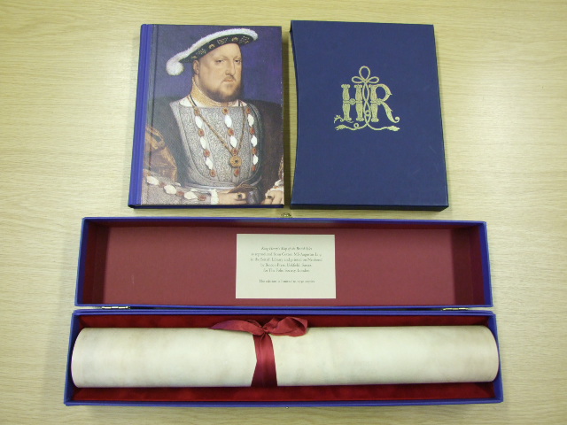
Barber, Peter - King Henry's Map of the British Isles
We buy and sell items like these, so please contact us if you have similar items for sale, and we will make you an offer if we are interested.
To check if we have this item, or similar items, in stock, please click the Check Stock link below. Alternatively, use the links on the left to search our large online database of items for sale, or to visit the rest of the site.
Check Stock
Barber, Peter - King Henry's Map of the British Isles (Published in by The Folio Society in 2009. Map size: 25.25" x 18.25". Box size: 19" x 3.75" x 3.75". Commentary: 160 pages with 48 colour illustrations. Commentary book size: 9.75" x 7.5". Limited to 2,750 copies. An historic royal map of King Henry's realm - This historic map of Britain, 'Angliae Figura', hung on the walls of Hampton Court Palace and is now available to own in facsimile. It is accompanied by a specially commissioned commentary volume by Peter Barber. At the end of the 1530s the Lord High Admiral noted that Henry VIII had become 'marvellously inflamed' by a new map. The 'Angliae Figura' had recently been presented to the King as a New Year's gift in 1537 by the Archdeacon of Rochester. Now housed in the British Library, this beautiful artefact has become one of the most famous representations of Henry's realm. Henry was the first English monarch fully to realise the potential of maps as practical instruments of government. The 'Angliae Figura' was both lavish and useful. Made from a single piece of vellum, it contains eight pinholes around its edges, suggesting that it was attached to a board. It was probably protected by curtains, which accounts for its pristine state. Containing the latest cartographical advances, it would have looked strikingly modern to its 16th-century viewers. The accuracy and detail of this map would have made it invaluable to Henry in implementing his policies, both foreign and domestic. In this limited edition the map is reproduced in facsimile at its actual size, tied with a silk ribbon and presented in a buckram covered box lined in fabric. The image is printed on both sides of Neobond a remarkable material which looks and feels like vellum and which lies flat when unrolled. The full significance of 'Angliae Figura' is explored in a specially commissioned commentary volume by Peter Barber, Head of Map Collections at the British Library. Tracing the development of Henry's interest in cartography, Barber shows how 'Angliae Figura' reflects the King's preoccupations and ambitions. The commentary also provides an overview of the complete history of the mapping of Britain from classical antiquity to Tudor times. At 160 pages, with 48 integrated colour pictures, it is a handsome volume and a substantial work of scholarship in its own right. )